

Routing for public transport
I. Routing for public transport.
- Adding route points
- In order to route for public transport please select the tab “Find route” and choose the option “I’m taking public transport”:
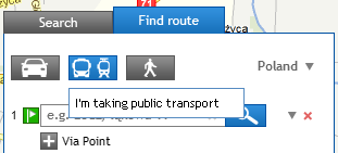
- Then please add the first and the last route point (using left panel or directly from a map using context menu under the right mouse button) – analogy to usual process of routing.
NOTE!
In the option of routing for public transport you can only determine the first and the last route point – you cannot define “via” points.
- In order to route for public transport please select the tab “Find route” and choose the option “I’m taking public transport”:
- Route parameters settingsAfter choosing the first and the last route point, the next step is to set the route parameters. To do this please choose the tab Additional options.
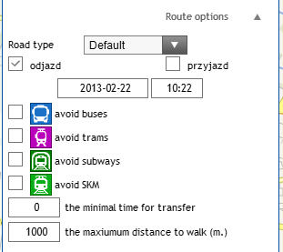
- One of the 4 types of route:
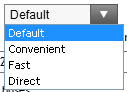
- default – optimal connection suggested by the system,
- convenient – including possibly the fewest (and the shortest) pedestrian crossings,
- fast – guaranteeing the fastest destination reaching,
- direct – including possibly the fewest changes.
- Date and time:
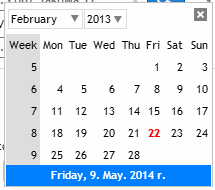
- After clicking onto the chosen date you will see a calendar enabling easier selecting the desired date:
- In the space concerning time please type the appropriate value.
- Throughout choosing “Departure” or “Arrival” you may define if the chosen values concerning time related to the moment, when you would like to start a journey or to the moment of finishing it (if e.g. you have to get to a theater at 6pm, please type the time into appropriate space and choose the option Arrival – system will point when, where and using which mean of public transport you should start the journey in order to reach the destination on time).
- After clicking onto the chosen date you will see a calendar enabling easier selecting the desired date:
- Avoid buses/Avoid trams options:
- Avoid buses/Avoid trams options enable to select which means of public transport you would like to avoid.
- The minimal time for transfer/ The maximum distance to walk:
- You may also define the minimal time for transfer (values given in minutes) as well as the maximum distance to walk (given in meters; due to the standard system includes maximum distance=1000m) – then system will consider only these connections, which fulfill given conditions.
- One of the 4 types of route:
- Routing.
After selecting the first and the last route points and setting desired route parameters, route will be automatically displayed.