FunkcjeFunctions
Mapa dla Jednostek Administracyjnych posiada następujące funkcje:
1. Wyświetlanie i przesuwanie mapy:
- Wyświetlanie mapy w dowolnej wielkości obszarze strony internetowej.
 - Przesuwanie mapy za pomocą myszki lub kursorów klawiatury.
 - Powiększanie mapy za pomocą paska skali mapy, kółka obrotowego myszki lub za pomocą opcji powiększania w prostokącie.
 - Pomniejszanie mapy za pomocą paska skali mapy lub kółka obrotowego myszki.
 - Wyszukiwanie adresów:
- Wyszukiwanie adresu na podstawie kodu pocztowego (zwrócenie wszystkich miejscowości z danego kodu pocztowego z miejscowością główną na początku).
 - Wyszukanie adresu na podstawie nazwy miejscowości, ulicy, numeru – system automatycznie podpowiada dostępne możliwości po wpisaniu kilku początkowych liter. W zależności od wpisanych informacji mapa wskazuje środek miejscowości, środek ulicy lub lokalizację konkretnego adresu.
 
 
2. Wyliczanie odległości:
- Wyliczanie trasy przejazdu między dowolnymi lokalizacjami wg. trzech metod: najszybsza, najkrótsza oraz najtańsza wraz z pełnym raportem przebiegu trasy podającym informacje o odległości, czasie, kosztach. Trasa ograniczona do maksymalnie 5 punktów.
 - Wyliczanie trasy przejazdu w zależności od wybranego środka lokomocji – pojazd osobowy, pojazd ciężarowy lub pieszy.
 - Wyliczanie trasy przejazdu z uwzględnieniem aktualnych utrudnień na drogach krajowych i autostradach.
 - Obliczanie odległości między punktami w linii prostej.
 
3. POI:
- Administracja
 - Bary i restauracje
 - Finanse
 - Kultura i rozrywka
 - Sport
 - Szkolnictwo
 - Stacje paliw
 - Transport i turystyka
 - Zakupy
 - Zdrowie
 
4. Inne funkcje:
- Możliwość zgłaszania uwag/błędów w mapie – zgłoszone poprawki w danych będą dostępne co kwartał.
 - Dodatkowo możliwe jest naniesienie specjalnych warstw takich jak np.:
- granica administracyjne,
 - szlaki turystyczne.
 
 - Obiekty 3D reprezentujące obiekty/budynki szczególnie interesujące wraz z opisem np. http://www.emapa.pl/budynki/swf/kra_002.swf.
 - Wyciągi narciarskie.
 - Inne warstwy POI – punkty widokowe.
 - Ścieżki rowerowe.
 - Mapę komunikacji miejskiej.
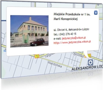
 - Tooltipy – okna z prezentacją (zdjęcie + krótki opis + link na stronę) dodanego obiektu:
Uwaga!
Wszystkie elementy naniesione w serwisie będą dodatkowo propagowane poprzez wykorzystanie w aplikacjach światowych potentatów oprogramowania do nawigacji takich, jak NavNGo, Igo oraz MIO.
 
Map for Administrative Units has the following features:
1. Map viewing and moving:
- Displaying a map in any size area of the website.
 - Moving the map with your mouse or keyboard cursors.
 - Zooming in the map using the map scale bar, the mouse wheel or by using the zoom in rectangle
 - Zooming out the map using the map scale bar or mouse wheel.
 - Address Search:
- a.The search for an address on the basis of a postal code (returning all the localities having certain postal code along with the main town at the beginning).
 - a.Finding the address on the name of the town, street, number – the system automatically tells us what is possible when you type a few first letters. Depending on the information entered, the map indicates the locality center, the center of the street or location of the particular address.
 
 
2. Calculating the distance:
- Route calculation between any locations using three methods: quickest, shortest and cheapest with a full report giving route information on distance, time, cost. Route limited to a maximum of 5 points.
 - Route calculation depending on the means of transport – passenger vehicle, truck or pedestrian.
 - Route calculation taking into account the current difficulties on the roads and highways.
 - Distance calculation between points in a straight line.
 
3. POIs:
The default application includes the following layers of POIs:
- Administrative Units
 - Pubs and restaurants
 - Financial institutions
 - Centers of culture and entertainment
 - Sports centers
 - Institutions of education
 - Petrol stations
 - Transportation and tourist centers
 - Shopping facilities
 - Health care centers
 
4. Other functions:
- Possibility to report comments / errors occurred on the map – proposed amendments to the data will be available on a quarterly basis.
 - You can additionally apply special layers, such as for example:
- administrative boundaries,
 - tourist trails.
 
 - 3D objects representing the objects / buildings of special interest with their descriptions, eg. http://www.emapa.pl/budynki/swf/kra_002.swf.
 - Ski-lifts
 - Other POIs layers – beauty spots
 - Bicycle lanes
 - Public transport map
 - Tooltips -window presentation (picture + a brief description+ link to the page) of the added object:
Attention!
All items marked on the site will be further promoted through the use in the applications of global navigation software tycoons such as NavNGo, Igo, and MIO.